Geolocate

Calvados topographic map

Click on the map to display elevation.

About this map

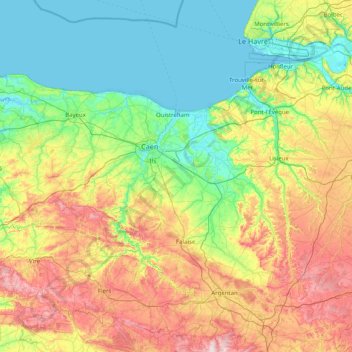
Name: Calvados topographic map, elevation, terrain.

Location: Calvados, Normandy, Metropolitan France, France (48.75166 -1.15977 49.42987 0.44663)

Average elevation: 117 m

Minimum elevation: -3 m

Maximum elevation: 407 m

Other topographic maps

Click on a map to view its topography, its elevation and its terrain.

Rouen

France > Normandy > Seine-Maritime > Rouen

Average elevation: 103 m

Gear up for your next adventure:

🚲Heavy Duty Bike Lock - Secure your bike at the trailhead or during stops
🧭GPS Handheld Device - Reliable GPS navigation for outdoor adventures
🧳Compression Sacks - Maximize space in your backpack by shrinking gear
🧤Rechargeable Heated Gloves - Extreme warmth for Canadian winter expeditions
🧢Sun Hat - Wide-brim hat for sun protection

As an Amazon Associate, this site earns from qualifying purchases at no extra cost to you.