Geolocate

Bagac topographic map

Click on the map to display elevation.

About this map

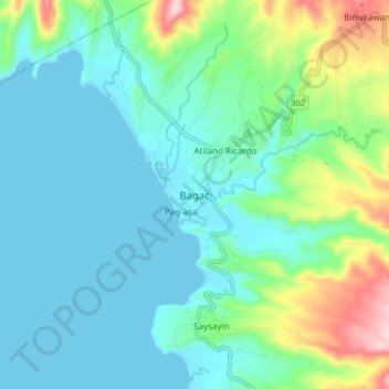
Name: Bagac topographic map, elevation, terrain.

Location: Bagac, Bataan, Central Luzon, 2107, Philippines (14.55674 120.35229 14.63674 120.43229)

Average elevation: 61 m

Minimum elevation: 0 m

Maximum elevation: 281 m

Other topographic maps

Click on a map to view its topography, its elevation and its terrain.

Subic Bay

Philippines > Bataan

Average elevation: 91 m

Cataning

Philippines > Bataan > Balanga

Average elevation: 11 m

Orani

Philippines > Bataan

Average elevation: 52 m

Orion

Philippines > Bataan

Average elevation: 115 m

Hermosa

Philippines > Bataan

Average elevation: 63 m

Limay

Philippines > Bataan

Average elevation: 117 m

Samal

Philippines > Bataan

Average elevation: 55 m

Morong

Philippines > Bataan

The most probable etymology comes from the Spanish word morón which refers to a hill which can be seen from the sea. Several towns in Spain and in Spanish colonies are also named Morón, namely Morón in Cuba; Morón de la Fronterra in Sevilla, Spain; and Morón in Buenos Aires, Argentina, to name a few.…

Average elevation: 111 m

Gear up for your next adventure:

🧤Thermal Hiking Gloves - Grip-enhanced gloves for cold-weather altitude trekking
🩹Moleskin Blister Pads - Direct protection for painful foot pressure points
🧊Insulated Water Bottle - Keeps drinks cold in summer and prevents freezing in winter
🧦Hiking Socks - Moisture-wicking and comfortable socks for long hikes
🥾All-Terrain Hiking Boots - Versatile boots for varied hiking conditions

As an Amazon Associate, this site earns from qualifying purchases at no extra cost to you.