
Saint Simons topographic map
Click on the map to display elevation.
About this map
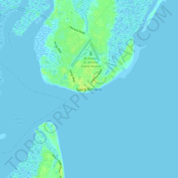
Name: Saint Simons topographic map, elevation, terrain.
Location: Saint Simons, Glynn County, Georgia, 31522, United States (31.09538 -81.42952 31.17538 -81.34952)
Average elevation: 2 m
Minimum elevation: -3 m
Maximum elevation: 14 m
Other topographic maps
Click on a map to view its topography, its elevation and its terrain.
Brunswick
United States > Georgia > Glynn County
The city is the lowest in the U.S. state of Georgia, with an elevation of only 10 to 14 feet (3.0 to 4.3 m) above sea level. According to the U.S. Census Bureau, Brunswick's land area is 32.4 square miles (83.8 km2). Its total area is 42.4 square miles (109.8 km2); 10.0 square miles (26.0 km2) of this is water.
Average elevation: 2 m