
Onekaka topographic map
Click on the map to display elevation.
About this map
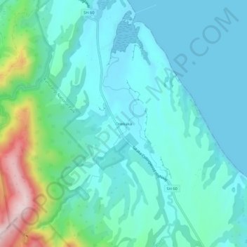
Name: Onekaka topographic map, elevation, terrain.
Location: Onekaka, Tasman, 7182, New Zealand (-40.78413 172.68827 -40.74413 172.72827)
Average elevation: 73 m
Minimum elevation: 0 m
Maximum elevation: 385 m
Other topographic maps
Click on a map to view its topography, its elevation and its terrain.
Spenser Mountains
New Zealand > Tasman > Hurunui District
The Spenser Mountains is a topographic landform in the northern South Island of New Zealand. Located at the southern end of the Nelson Lakes National Park and north of the Lewis Pass they form a natural border between the Canterbury and Tasman regions. Several peaks are named after characters in Edmund…
Average elevation: 1,310 m
Brown River
New Zealand > Tasman > Tasman District
The source of the Brown River is near Brown Hill (elevation 1,104 metres or 3,622 feet) and the river flows north from the ridgeline adjacent to this hill. The Heaphy Track is on the south side of that ridgeline, with the river's source roughly halfway between Aorere Shelter and Flanagans Corner (the track's…
Average elevation: 625 m
Spenser Mountains
New Zealand > Tasman > Hurunui District
The Spenser Mountains is a topographic landform in the northern South Island of New Zealand. Located at the southern end of the Nelson Lakes National Park and north of the Lewis Pass they form a natural border between the Canterbury and Tasman regions. Several peaks are named after characters in Edmund…
Average elevation: 1,310 m