Geolocate

Kavanoor topographic map

Click on the map to display elevation.

About this map

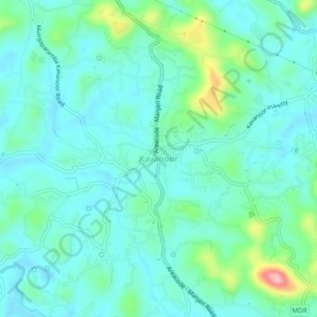
Name: Kavanoor topographic map, elevation, terrain.

Location: Kavanoor, Ernad, Malappuram, Kerala, 673644, India (11.17464 76.04455 11.21464 76.08455)

Average elevation: 44 m

Minimum elevation: 13 m

Maximum elevation: 164 m

Other topographic maps

Click on a map to view its topography, its elevation and its terrain.

Vandoor

India > Kerala > Ernad

Average elevation: 59 m

Alathurpadi

India > Kerala > Ernad > Malappuram

Average elevation: 64 m

Manjeri

India > Kerala > Ernad

Manjeri is located at 11°07′N 76°07′E / 11.12°N 76.12°E / 11.12; 76.12. It has an average elevation of 38 metres (124 feet) from sea level.

Average elevation: 58 m

Irumbuzhi

India > Kerala > Ernad > Malappuram

Average elevation: 43 m

Malappuram

India > Kerala > Ernad > Malappuram

Average elevation: 62 m

Areekkode

India > Kerala > Ernad

Average elevation: 112 m

Malappuram

India > Kerala > Ernad

Average elevation: 56 m

Kavanur

India > Kerala > Ernad > Kavanoor

Average elevation: 42 m

Manjeri

India > Kerala > Ernad

Manjeri is located at 11°07′N 76°07′E / 11.12°N 76.12°E / 11.12; 76.12. It has an average elevation of 38 metres (124 feet) from sea level.

Average elevation: 58 m

Gear up for your next adventure:

🧭Orienteering Kit - Tools for map reading and navigation in the wild
🧣Merino Neck Gaiter - Protects against wind, sun, and cold at high altitudes
🛌Down Sleeping Bag - Superior warmth-to-weight ratio for cold nights
🦌Outdoor Trail Camera - Monitor wildlife activity near your favorite spots
🔦UV Flashlight - Detect minerals or specific insects in the dark

As an Amazon Associate, this site earns from qualifying purchases at no extra cost to you.