Geolocate

Pajang topographic map

Click on the map to display elevation.

About this map

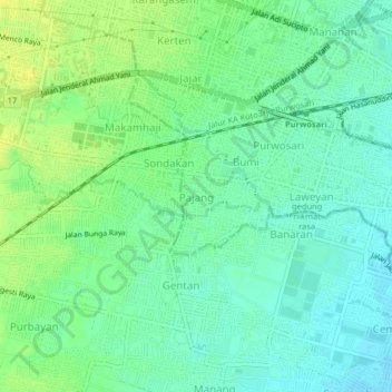
Name: Pajang topographic map, elevation, terrain.

Location: Pajang, Surakarta, Central Java, 57147, Indonesia (-7.59010 110.76518 -7.55010 110.80518)

Average elevation: 103 m

Minimum elevation: 95 m

Maximum elevation: 113 m

Gear up for your next adventure:

🔨Vehicle Emergency Tool - Safety tool for remote road trips to trailheads
💧Hydration Bladder - Hands-free hydration solution for long treks
🛶Kayak Dry Bag - Waterproof storage for kayaking adventures
🧭Orienteering Kit - Tools for map reading and navigation in the wild
Camping Essentials - All-in-one gear for a comfortable camping trip

As an Amazon Associate, this site earns from qualifying purchases at no extra cost to you.