
Make a donation
Gear up for your next adventure:
As an Amazon Associate, this site earns from qualifying purchases at no extra cost to you.
St. Goar-Fellen topographic map
Click on the map to display elevation.
Make a donation
Gear up for your next adventure:
As an Amazon Associate, this site earns from qualifying purchases at no extra cost to you.
About this map
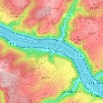
Name: St. Goar-Fellen topographic map, elevation, terrain.
Average elevation: 208 m
Minimum elevation: 68 m
Maximum elevation: 328 m
Make a donation
Gear up for your next adventure:
As an Amazon Associate, this site earns from qualifying purchases at no extra cost to you.
Other topographic maps
Click on a map to view its topography, its elevation and its terrain.
Burg Rheinfels
Deutschland > Rheinland-Pfalz > Rhein-Hunsrück-Kreis > Sankt Goar > Biebernheim
Nachdem 1402 die Ober- und Niedergrafschaft wieder vereinigt wurden, blieb die Residenz auf Burg Rheinfels. Unter Graf Johann IV. und seinem Sohn Philipp erlangte das höfische Leben im 15. Jahrhundert auf Burg Rheinfels seinen Höhepunkt. Nach neueren Erkenntnissen wurde erst unter Philipp der runde Bergfried…
Average elevation: 173 m