
Make a donation
Gear up for your next adventure:
As an Amazon Associate, this site earns from qualifying purchases at no extra cost to you.
Filicudi topographic map
Click on the map to display elevation.
Make a donation
Gear up for your next adventure:
As an Amazon Associate, this site earns from qualifying purchases at no extra cost to you.
Filicudi
Die etwa 250 Bewohner und einige Künstler, die sich hier niedergelassen haben, wie der inzwischen verstorbene Designer Ettore Sottsass, leben vorwiegend am Südhang von Filicudi, im Fischerhafen Pecorini oder in Valdichiesa, das auf einer Höhe von 280 m liegt.
Make a donation
Gear up for your next adventure:
As an Amazon Associate, this site earns from qualifying purchases at no extra cost to you.
About this map
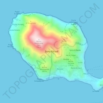
Name: Filicudi topographic map, elevation, terrain.
Location: Filicudi, Lipari, Messina, Sizilien, Italien (38.55329 14.53946 38.58607 14.59385)
Average elevation: 107 m
Minimum elevation: 0 m
Maximum elevation: 750 m
Make a donation
Gear up for your next adventure:
As an Amazon Associate, this site earns from qualifying purchases at no extra cost to you.
Other topographic maps
Click on a map to view its topography, its elevation and its terrain.
Stromboli
Italien > Sizilien > Messina > Lipari
Stromboli zählt mit seinen Nachbarinseln Lipari, Salina, Vulcano, Panarea, Filicudi und Alicudi zur Inselgruppe der Äolischen oder Liparischen Inseln im Tyrrhenischen Meer. Die Höhe der steil aus dem Wasser aufragenden, nahezu kegelförmigen Insel beträgt vom Meeresspiegel aus 926 Meter, in anderen Belegen…
Average elevation: 372 m
Make a donation
Gear up for your next adventure:
As an Amazon Associate, this site earns from qualifying purchases at no extra cost to you.