
Weaverham topographic map
Click on the map to display elevation.
About this map
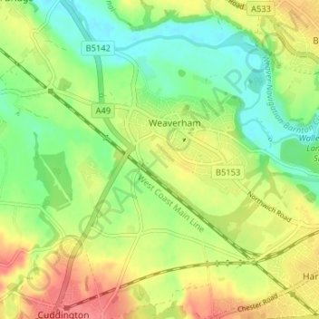
Name: Weaverham topographic map, elevation, terrain.
Location: Weaverham, Cheshire West and Chester, England, United Kingdom (53.24238 -2.60740 53.27363 -2.54262)
Average elevation: 37 m
Minimum elevation: 6 m
Maximum elevation: 74 m
Other topographic maps
Click on a map to view its topography, its elevation and its terrain.
Little Stanney Wood
United Kingdom > England > Cheshire West and Chester > Stoak > Little Stanney
Average elevation: 11 m