Geolocate

Tampomas topographic map

Click on the map to display elevation.

About this map

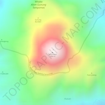
Name: Tampomas topographic map, elevation, terrain.

Location: Tampomas, Sumedang, West Java, Java, Indonesia (-6.76451 107.96036 -6.76441 107.96046)

Average elevation: 1,248 m

Minimum elevation: 940 m

Maximum elevation: 1,672 m

Other topographic maps

Click on a map to view its topography, its elevation and its terrain.

Situ II ITB

Indonesia > West Java > Sumedang > Jatinangor

Average elevation: 726 m

Gear up for your next adventure:

🔋Lithium AA Batteries - Long-lasting power that performs in extreme cold
🧣Merino Neck Gaiter - Protects against wind, sun, and cold at high altitudes
🗺️Topographic Maps - Detailed maps to explore trails, mountains, and wilderness areas
🥾Durable Hiking Shoes - Long-lasting shoes for frequent hiking
🧢Sun Protection Cap - Breathable cap to protect from sun exposure

As an Amazon Associate, this site earns from qualifying purchases at no extra cost to you.