
Make a donation
Gear up for your next adventure:
As an Amazon Associate, this site earns from qualifying purchases at no extra cost to you.
Kontich topographic map
Click on the map to display elevation.
Make a donation
Gear up for your next adventure:
As an Amazon Associate, this site earns from qualifying purchases at no extra cost to you.
Kontich
Zo vertelt een oude volkssage dat Kontich aan zijn naam zou zijn gekomen doordat er een reus met zijn ene voet op de Onze-Lieve-Vrouwekathedraal te Antwerpen zou hebben gestaan en met zijn andere op de Sint-Romboutstoren van Mechelen. Ter hoogte van zijn achterwerk zou Kont-ich hebben gelegen.
Make a donation
Gear up for your next adventure:
As an Amazon Associate, this site earns from qualifying purchases at no extra cost to you.
About this map
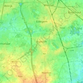
Name: Kontich topographic map, elevation, terrain.
Location: Kontich, Antwerpen, Vlaanderen, 2550, België (51.09533 4.40548 51.17533 4.48548)
Average elevation: 16 m
Minimum elevation: 3 m
Maximum elevation: 32 m
Make a donation
Gear up for your next adventure:
As an Amazon Associate, this site earns from qualifying purchases at no extra cost to you.
Other topographic maps
Click on a map to view its topography, its elevation and its terrain.