Geolocate

Oceanside topographic map

Click on the map to display elevation.

About this map

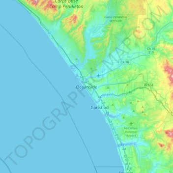
Name: Oceanside topographic map, elevation, terrain.

Location: Oceanside, San Diego County, California, 92054, United States (33.03587 -117.53948 33.35587 -117.21948)

Average elevation: 53 m

Minimum elevation: -5 m

Maximum elevation: 453 m

Other topographic maps

Click on a map to view its topography, its elevation and its terrain.

Gear up for your next adventure:

🥾All-Terrain Hiking Boots - Versatile boots for varied hiking conditions
🥾Mountaineering Boots - Supportive boots for climbing and high-altitude hiking
🧭GPS Outdoor Watch - Smart watch for navigation and fitness tracking in nature
🥾Lightweight Hiking Shoes - Comfortable shoes for day hikes
🎒Backpack Rain Cover - External shield to keep your entire pack dry

As an Amazon Associate, this site earns from qualifying purchases at no extra cost to you.