Geolocate

Riego topographic map

Click on the map to display elevation.

About this map

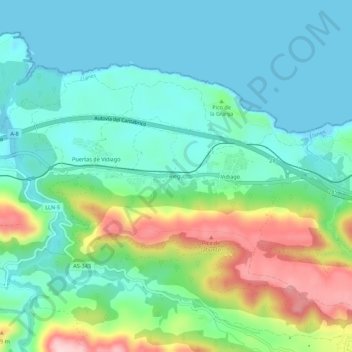
Name: Riego topographic map, elevation, terrain.

Location: Riego, Llanes, Asturias, 33598, España (43.37620 -4.69379 43.41620 -4.65379)

Average elevation: 68 m

Minimum elevation: 0 m

Maximum elevation: 249 m

Other topographic maps

Click on a map to view its topography, its elevation and its terrain.

Meré

España > Asturias > Llanes

Average elevation: 351 m

Río de Nueva

España > Asturias > Llanes > Picones

Average elevation: 25 m

Gear up for your next adventure:

🥾Lightweight Hiking Boots - Boots for comfort and mobility on long hikes
🚲Bike Repair Kit - Essential tools for on-trail mechanical issues
🥤Collapsible Travel Cup - Saves space and weight in your mess kit
🥾Waterproof Hiking Boots - Essential footwear for rugged terrain and wet Canadian trails
🧤Insulated Winter Gloves - Heavy-duty protection for sub-zero Canadian adventures

As an Amazon Associate, this site earns from qualifying purchases at no extra cost to you.