Geolocate

Saint-Luc topographic map

Click on the map to display elevation.

About this map

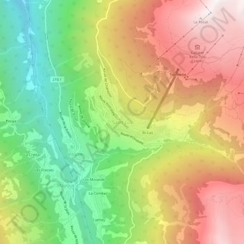
Name: Saint-Luc topographic map, elevation, terrain.

Location: Saint-Luc, Anniviers, Sierre, Wallis, 3961, Switzerland (46.20056 7.57649 46.24056 7.61649)

Average elevation: 1,698 m

Minimum elevation: 847 m

Maximum elevation: 2,610 m

Other topographic maps

Click on a map to view its topography, its elevation and its terrain.

Lac de Châteaupré

Switzerland > Wallis > Sierre > Anniviers

Average elevation: 2,646 m

Gear up for your next adventure:

Camping Essentials - All-in-one gear for a comfortable camping trip
🛶Kayak Dry Bag - Waterproof storage for kayaking adventures
🎒Hiking Daypack - Lightweight and durable backpacks for day trips and excursions
🧶550 Survival Paracord - Versatile utility cord for emergency repairs and rigging
🧭GPS Tracker - Track your location in remote areas safely

As an Amazon Associate, this site earns from qualifying purchases at no extra cost to you.