
Make a donation
Gear up for your next adventure:
As an Amazon Associate, this site earns from qualifying purchases at no extra cost to you.
Patscherkofel topographic map
Click on the map to display elevation.
Make a donation
Gear up for your next adventure:
As an Amazon Associate, this site earns from qualifying purchases at no extra cost to you.
Patscherkofel
Das Landschaftsschutzgebiet Patscherkofel-Zirmberg gehört zu den Tuxer Voralpen und liegt unmittelbar südlich von Innsbruck. Der Patscherkofel und die sich nach Osten fortsetzende Höhenkette bieten gute Ausblicke sowohl nach Norden über das Inntal und zur Nordkette als auch nach Süden in den zentralen Teil der Alpen.
Make a donation
Gear up for your next adventure:
As an Amazon Associate, this site earns from qualifying purchases at no extra cost to you.
About this map
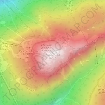
Name: Patscherkofel topographic map, elevation, terrain.
Average elevation: 1,776 m
Minimum elevation: 1,163 m
Maximum elevation: 2,250 m
Make a donation
Gear up for your next adventure:
As an Amazon Associate, this site earns from qualifying purchases at no extra cost to you.