
Make a donation
Gear up for your next adventure:
As an Amazon Associate, this site earns from qualifying purchases at no extra cost to you.
Pine Bluff topographic map
Click on the map to display elevation.
Make a donation
Gear up for your next adventure:
As an Amazon Associate, this site earns from qualifying purchases at no extra cost to you.
Pine Bluff
The city is situated in the Southeast section of the Arkansas Delta and straddles the Arkansas Timberlands region to its west. Its topography is flat with wide expanses of farmland, similar to other places in the Delta Lowlands. Pine Bluff has numerous creeks, streams, and bayous, including Bayou Bartholomew, the longest bayou in the world and the second most ecologically diverse stream in the United States. Large bodies of water include Lake Pine Bluff, Lake Langhofer (Slack Water Harbor), and the Arkansas River.
Make a donation
Gear up for your next adventure:
As an Amazon Associate, this site earns from qualifying purchases at no extra cost to you.
About this map
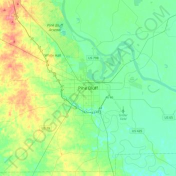
Name: Pine Bluff topographic map, elevation, terrain.
Location: Pine Bluff, Jefferson County, Arkansas, 71601, United States (34.05571 -92.17404 34.37571 -91.85404)
Average elevation: 73 m
Minimum elevation: 50 m
Maximum elevation: 136 m
Make a donation
Gear up for your next adventure:
As an Amazon Associate, this site earns from qualifying purchases at no extra cost to you.