Geolocate

Näset topographic map

Click on the map to display elevation.

About this map

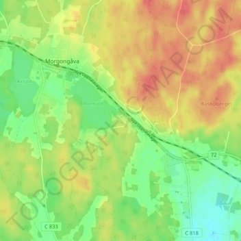
Name: Näset topographic map, elevation, terrain.

Location: Näset, Morgongåva, Heby kommun, Uppsala län, 744 51, Sverige (59.90383 16.96212 59.94383 17.00212)

Average elevation: 70 m

Minimum elevation: 42 m

Maximum elevation: 96 m

Gear up for your next adventure:

🥾Waterproof Hiking Shoes - Durable shoes for wet and rugged trails
💡LED Camping Lantern - Illuminate your campsite with long-lasting lanterns
Tent Footprint - Protect tent floor and increase durability
🥽Outdoor Goggles - Protective eyewear for outdoor activities
🧭GPS Handheld Device - Reliable GPS navigation for outdoor adventures

As an Amazon Associate, this site earns from qualifying purchases at no extra cost to you.