
Make a donation
Gear up for your next adventure:
As an Amazon Associate, this site earns from qualifying purchases at no extra cost to you.
Krapina topographic map
Click on the map to display elevation.
Make a donation
Gear up for your next adventure:
As an Amazon Associate, this site earns from qualifying purchases at no extra cost to you.
Krapina
Since records began in 1993, the highest temperature recorded at the local weather station at an elevation of 202 metres (663 ft) was 39.1 °C (102.4 °F), on 8 August 2017. The coldest temperature was −18.5 °C (−1.3 °F), on 10 February 2005. At the KL station, the coldest temperature was −22.0 °C (−7.6 °F), on 13 February 1985.
Make a donation
Gear up for your next adventure:
As an Amazon Associate, this site earns from qualifying purchases at no extra cost to you.
About this map
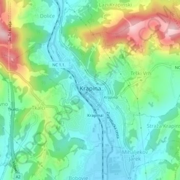
Name: Krapina topographic map, elevation, terrain.
Location: Krapina, Grad Krapina, Krapina-Zagorje County, 49000, Croatia (46.14989 15.85762 46.17512 15.88098)
Average elevation: 253 m
Minimum elevation: 172 m
Maximum elevation: 430 m
Make a donation
Gear up for your next adventure:
As an Amazon Associate, this site earns from qualifying purchases at no extra cost to you.
Other topographic maps
Click on a map to view its topography, its elevation and its terrain.
Make a donation
Gear up for your next adventure:
As an Amazon Associate, this site earns from qualifying purchases at no extra cost to you.