
Thank you for supporting this site ❤️
Make a donation
Make a donation
Gear up for your next adventure:
As an Amazon Associate, this site earns from qualifying purchases at no extra cost to you.
Montepoli topographic map
Click on the map to display elevation.
Thank you for supporting this site ❤️
Make a donation
Make a donation
Gear up for your next adventure:
As an Amazon Associate, this site earns from qualifying purchases at no extra cost to you.
About this map
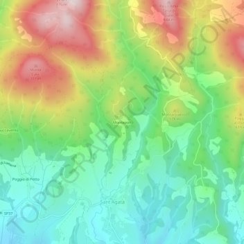
Name: Montepoli topographic map, elevation, terrain.
Location: Montepoli, Scarperia e San Piero, Firenze, Toscane, Italië (44.01367 11.31713 44.05367 11.35713)
Average elevation: 488 m
Minimum elevation: 271 m
Maximum elevation: 840 m
Thank you for supporting this site ❤️
Make a donation
Make a donation
Gear up for your next adventure:
As an Amazon Associate, this site earns from qualifying purchases at no extra cost to you.