Geolocate

Kranjska Gora topographic map

Click on the map to display elevation.

About this map

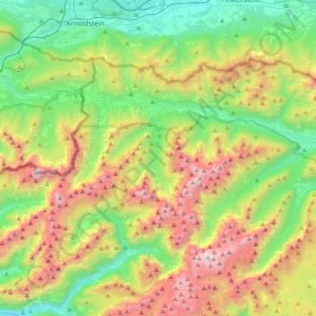
Name: Kranjska Gora topographic map, elevation, terrain.

Location: Kranjska Gora, Slovenia (46.37697 13.67742 46.52346 14.01136)

Average elevation: 1,287 m

Minimum elevation: 428 m

Maximum elevation: 2,802 m

Other topographic maps

Click on a map to view its topography, its elevation and its terrain.

Kamna Gorica

Slovenia > Radovljica

Average elevation: 555 m

Jesenik

Slovenia > Velenje

Average elevation: 587 m

Nova vas

Slovenia > Sežana

Average elevation: 357 m

Zamedveje

Slovenia > Plave

Average elevation: 372 m

Kredarica

Slovenia

Average elevation: 1,520 m

Polhov Gradec

Slovenia

Average elevation: 507 m

Bela

Slovenia > Kamnik > Bela

Average elevation: 760 m

Gear up for your next adventure:

🥾Mountain Hiking Shoes - Shoes with superior grip for mountainous terrain
🥫Freeze-Dried Meals - Lightweight, high-calorie nutrition for multi-day treks
🥾Waterproof Hiking Boots - Boots keeping your feet dry in wet conditions
🧦Crew Hiking Socks - Comfortable socks for long-distance hikes
🧥Packable Rain Jacket - Breathable waterproof layer for unpredictable weather

As an Amazon Associate, this site earns from qualifying purchases at no extra cost to you.