Geolocate

Uribe topographic map

Click on the map to display elevation.

About this map

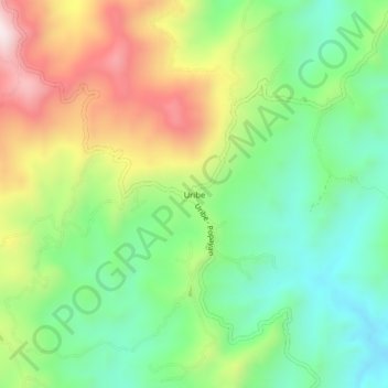
Name: Uribe topographic map, elevation, terrain.

Location: Uribe, El Tambo, Centro, Cauca, RAP Pacífico, Colombia (2.53286 -76.87391 2.57286 -76.83391)

Average elevation: 1,877 m

Minimum elevation: 1,629 m

Maximum elevation: 2,267 m

Other topographic maps

Click on a map to view its topography, its elevation and its terrain.

Río Sucio

Colombia > Cauca > El Tambo

Average elevation: 1,730 m

Gear up for your next adventure:

Camping Tent - Weather-resistant tents suitable for 2 to 6 people
🦯Trekking Poles - Reduced impact on joints for steep topographic climbs
🚲Bike Repair Kit - Essential tools for on-trail mechanical issues
🦶Anti-Blister Balm - Prevents friction and hotspots during long ascents
🧴Outdoor Sunscreen - High SPF protection for high-altitude UV exposure

As an Amazon Associate, this site earns from qualifying purchases at no extra cost to you.