Geolocate

Paupack Township topographic map

Click on the map to display elevation.

About this map

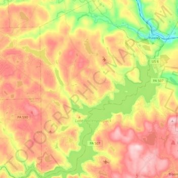
Name: Paupack Township topographic map, elevation, terrain.

Location: Paupack Township, Wayne County, Pennsylvania, 18438, United States (41.36742 -75.30014 41.50460 -75.18613)

Average elevation: 411 m

Minimum elevation: 261 m

Maximum elevation: 534 m

Other topographic maps

Click on a map to view its topography, its elevation and its terrain.

Gouldsboro

United States > Pennsylvania > Wayne County

Average elevation: 589 m

West Hawley

United States > Pennsylvania > Wayne County > Hawley

Average elevation: 346 m

Beach Lake

United States > Pennsylvania > Wayne County

Average elevation: 393 m

Newfoundland

United States > Pennsylvania > Wayne County

Average elevation: 456 m

Hamlin

United States > Pennsylvania > Wayne County

Average elevation: 459 m

Lake Ariel

United States > Pennsylvania > Wayne County

Average elevation: 453 m

Milanville

United States > Pennsylvania > Wayne County

Average elevation: 298 m

Gear up for your next adventure:

🥤Collapsible Travel Cup - Saves space and weight in your mess kit
🚲MTB Frame Bag - Carry tools and maps directly on your bicycle frame
Camping Coffee Maker - Brew fresh coffee anywhere on the topographic map
🥾Trekking Poles - Adjustable trekking poles to reduce knee stress and improve stability
🧭GPS Handheld Device - Reliable GPS navigation for outdoor adventures

As an Amazon Associate, this site earns from qualifying purchases at no extra cost to you.