Geolocate

Greerton topographic map

Click on the map to display elevation.

About this map

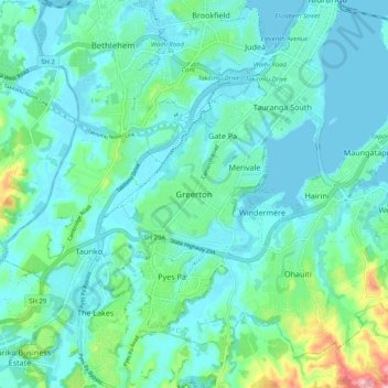
Name: Greerton topographic map, elevation, terrain.

Location: Greerton, Tauranga City, Bay of Plenty, 3112, New Zealand (-37.76621 176.09279 -37.68621 176.17279)

Average elevation: 31 m

Minimum elevation: -1 m

Maximum elevation: 173 m

Other topographic maps

Click on a map to view its topography, its elevation and its terrain.

Welcome Bay

New Zealand > Bay of Plenty > Tauranga City

Average elevation: 49 m

Bayfair

New Zealand > Bay of Plenty > Tauranga City

Average elevation: 8 m

Tauranga

New Zealand > Bay of Plenty > Tauranga City

Average elevation: 63 m

Gear up for your next adventure:

🕶️Polarized Sunglasses - Reduces glare from snow and water at high elevations
Camping Tent - Weather-resistant tents suitable for 2 to 6 people
👖Convertible Hiking Pants - Zip-off legs to adapt to changing weather conditions
🛰️Satellite Messenger - Emergency communication for areas with no cell service
🏃Hydration Running Vest - Carry water and maps close to your body for speed

As an Amazon Associate, this site earns from qualifying purchases at no extra cost to you.