
Thank you for supporting this site ❤️
Make a donation
Make a donation
Gear up for your next adventure:
As an Amazon Associate, this site earns from qualifying purchases at no extra cost to you.
Villazón topographic map
Click on the map to display elevation.
Thank you for supporting this site ❤️
Make a donation
Make a donation
Gear up for your next adventure:
As an Amazon Associate, this site earns from qualifying purchases at no extra cost to you.
About this map
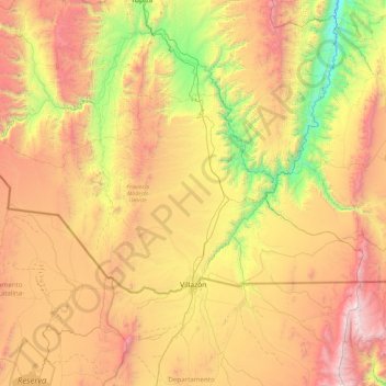
Name: Villazón topographic map, elevation, terrain.
Location: Villazón, Provincia Modesto Omiste, Potosí, Bolivia (-22.11160 -66.12347 -21.65703 -65.18065)
Average elevation: 3,557 m
Minimum elevation: 2,444 m
Maximum elevation: 4,997 m
Thank you for supporting this site ❤️
Make a donation
Make a donation
Gear up for your next adventure:
As an Amazon Associate, this site earns from qualifying purchases at no extra cost to you.
Other topographic maps
Click on a map to view its topography, its elevation and its terrain.
San Marcos
Bolivia > Potosí > Provincia Modesto Omiste > Villazón > San Marcos
Average elevation: 3,057 m