
Make a donation
Gear up for your next adventure:
As an Amazon Associate, this site earns from qualifying purchases at no extra cost to you.
Timhadit topographic map
Click on the map to display elevation.
Make a donation
Gear up for your next adventure:
As an Amazon Associate, this site earns from qualifying purchases at no extra cost to you.
Timhadit
Timahdite (en tamazight ⵜⵉⵎⴰⵃⴹⵉⵜ, en arabe : تمحضيت) est une ville du Maroc. Elle est située dans la région de Fès-Meknès, à 1 800 m d'altitude, en plein cœur du Moyen Atlas, dans une zone au climat rude.
Make a donation
Gear up for your next adventure:
As an Amazon Associate, this site earns from qualifying purchases at no extra cost to you.
About this map
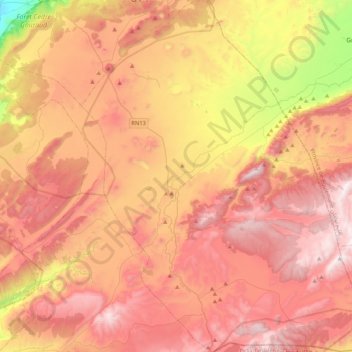
Name: Timhadit topographic map, elevation, terrain.
Average elevation: 1,902 m
Minimum elevation: 1,132 m
Maximum elevation: 2,442 m
Make a donation
Gear up for your next adventure:
As an Amazon Associate, this site earns from qualifying purchases at no extra cost to you.
Other topographic maps
Click on a map to view its topography, its elevation and its terrain.
Make a donation
Gear up for your next adventure:
As an Amazon Associate, this site earns from qualifying purchases at no extra cost to you.
Make a donation
Gear up for your next adventure:
As an Amazon Associate, this site earns from qualifying purchases at no extra cost to you.