
Volvic topographic map
Click on the map to display elevation.
About this map
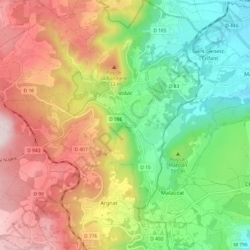
Name: Volvic topographic map, elevation, terrain.
Average elevation: 589 m
Minimum elevation: 361 m
Maximum elevation: 871 m
Other topographic maps
Click on a map to view its topography, its elevation and its terrain.
Contournat
France > Auvergne-Rhône-Alpes > Puy-de-Dôme > Saint-Julien-de-Coppel
Average elevation: 474 m
La Live
France > Auvergne-Rhône-Alpes > Puy-de-Dôme > Glaine-Montaigut > Glaine
Average elevation: 363 m
Soulace
France > Auvergne-Rhône-Alpes > Puy-de-Dôme > Marsac-en-Livradois > Flaittes
Average elevation: 621 m
Les Gicons
France > Auvergne-Rhône-Alpes > Puy-de-Dôme > Montaigut-en-Combraille
Average elevation: 608 m
Beaune-le-Chaud
France > Auvergne-Rhône-Alpes > Puy-de-Dôme > Saint-Genès-Champanelle
Average elevation: 941 m
La Graissière
France > Auvergne-Rhône-Alpes > Puy-de-Dôme > Saint-Genès-Champanelle
Average elevation: 984 m