Geolocate

Eierberg topographic map

Click on the map to display elevation.

Eierberg

Das amtliche Mitteilungsblatt ist der Eichberg-Kurier. Als Heimatblatt für Lichtenberg und Kleindittmannsdorf erscheint es seit Mai 1994 monatlich in einer Auflagenhöhe von derzeit 884 Exemplaren. Über das örtliche Fernsehkabelnetz kann zudem die Kabelzeitung für Lichtenberg, Kleindittmannsdorf, Leppersdorf und Mittelbach empfangen werden.

Wikipedia (CC-BY-SA 3.0)

About this map

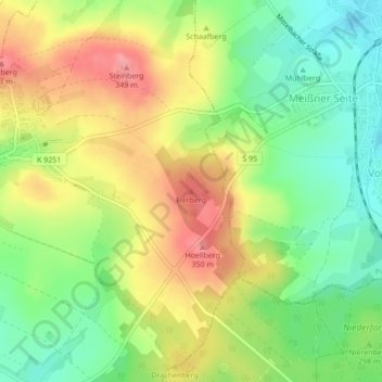
Name: Eierberg topographic map, elevation, terrain.

Location: Eierberg, Lichtenberg, Pulsnitz, Bautzen, Sachsen, 01896, Deutschland (51.17389 13.98905 51.17399 13.98915)

Average elevation: 305 m

Minimum elevation: 261 m

Maximum elevation: 355 m

Other topographic maps

Click on a map to view its topography, its elevation and its terrain.

Lauterbachtal

Deutschland > Sachsen > Bautzen > Lichtenberg

Average elevation: 249 m

Gear up for your next adventure:

🚲Heavy Duty Bike Lock - Secure your bike at the trailhead or during stops
🧊Portable Cooler - Keep food and drinks cold during outdoor adventures
🚲Handlebar Phone Mount - View topographic-map.com live while cycling
🛶Waterproof Dry Bags - Keep electronics and clothes dry during river crossings
🧦Hiking Socks - Moisture-wicking and comfortable socks for long hikes

As an Amazon Associate, this site earns from qualifying purchases at no extra cost to you.