Geolocate

Rait topographic map

Click on the map to display elevation.

About this map

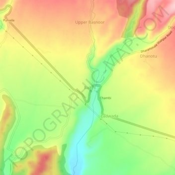
Name: Rait topographic map, elevation, terrain.

Location: Rait, Shahpur, Kangra, Himachal Pradesh, 176214, India (32.16631 76.19551 32.20631 76.23551)

Average elevation: 709 m

Minimum elevation: 613 m

Maximum elevation: 795 m

Gear up for your next adventure:

Bushcraft Tarp - Versatile emergency shelter or gear protection
🥾Hiking Boots - Sturdy boots providing ankle support and traction on rugged trails
🕶️Polarized Sunglasses - Reduces glare from snow and water at high elevations
🔥Emergency Fire Starter - Reliable ignition source for all weather conditions
🏃Hydration Running Vest - Carry water and maps close to your body for speed

As an Amazon Associate, this site earns from qualifying purchases at no extra cost to you.