Geolocate

Maryville topographic map

Click on the map to display elevation.

About this map

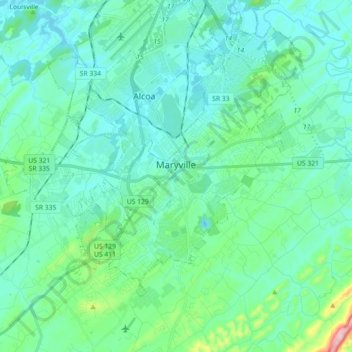
Name: Maryville topographic map, elevation, terrain.

Location: Maryville, Blount County, Tennessee, United States (35.70184 -84.09410 35.78396 -83.91481)

Average elevation: 303 m

Minimum elevation: 247 m

Maximum elevation: 628 m

Gear up for your next adventure:

🧴Insect Repellent - Protect yourself from bugs during outdoor adventures
🛏️Sleeping Bag - Warm and compact sleeping bags for outdoor camping
🧼Biodegradable Camp Soap - Environmentally friendly cleaning for gear and body
Camping Coffee Maker - Brew fresh coffee anywhere on the topographic map
🧥Thermal Layer - Insulating layer for cold outdoor conditions

As an Amazon Associate, this site earns from qualifying purchases at no extra cost to you.