Geolocate

Calvera topographic map

Click on the map to display elevation.

About this map

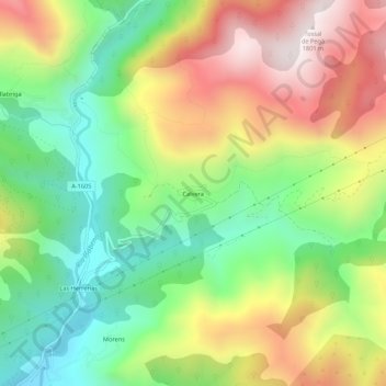
Name: Calvera topographic map, elevation, terrain.

Location: Calvera, Beranuy, Ribagorza, Huesca, Aragón, España (42.36800 0.59314 42.40800 0.63314)

Average elevation: 1,292 m

Minimum elevation: 920 m

Maximum elevation: 1,782 m

Gear up for your next adventure:

💡LED Headlamp - Hands-free illumination for night hiking and camping
🔭Outdoor Binoculars - Lightweight binoculars for birdwatching and hiking
🔦LED Headtorch - Bright and durable light for night activities
💧Hydration Pack - Hands-free hydration system for long hikes
Lightweight Backpacking Tent - Compact tent for efficient hiking trips

As an Amazon Associate, this site earns from qualifying purchases at no extra cost to you.