
Make a donation
Gear up for your next adventure:
As an Amazon Associate, this site earns from qualifying purchases at no extra cost to you.
Devenport topographic map
Click on the map to display elevation.
Make a donation
Gear up for your next adventure:
As an Amazon Associate, this site earns from qualifying purchases at no extra cost to you.
About this map
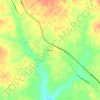
Name: Devenport topographic map, elevation, terrain.
Average elevation: 336 m
Minimum elevation: 309 m
Maximum elevation: 357 m
Make a donation
Gear up for your next adventure:
As an Amazon Associate, this site earns from qualifying purchases at no extra cost to you.
Other topographic maps
Click on a map to view its topography, its elevation and its terrain.
McMinnville
United States > Tennessee > Warren County
According to the United States Census Bureau, the city has a total area of 10.0 square miles (26 km2), all land. McMinnville lies at an elevation of 968 feet (295 m), as it sits along the Eastern Highland Rim near the base of the Cumberland Plateau. The city is drained primarily by the Barren Fork, a tributary…
Average elevation: 302 m