
Make a donation
Gear up for your next adventure:
As an Amazon Associate, this site earns from qualifying purchases at no extra cost to you.
Soulan topographic map
Click on the map to display elevation.
Make a donation
Gear up for your next adventure:
As an Amazon Associate, this site earns from qualifying purchases at no extra cost to you.
Soulan
La superficie cadastrale de la commune publiée par l’Insee, qui sert de références dans toutes les statistiques, est de 23,76 km2. La superficie géographique, issue de la BD Topo, composante du Référentiel à grande échelle produit par l'IGN, est quant à elle de 23,91 km2. Son relief est particulièrement escarpé puisque la dénivelée maximale atteint 949 mètres. L'altitude du territoire varie entre 466 m et 1 415 m.
Make a donation
Gear up for your next adventure:
As an Amazon Associate, this site earns from qualifying purchases at no extra cost to you.
About this map
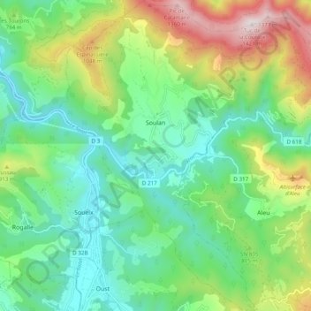
Name: Soulan topographic map, elevation, terrain.
Average elevation: 744 m
Minimum elevation: 445 m
Maximum elevation: 1,407 m
Make a donation
Gear up for your next adventure:
As an Amazon Associate, this site earns from qualifying purchases at no extra cost to you.
Other topographic maps
Click on a map to view its topography, its elevation and its terrain.
Grotte Bernard
France > Occitanie > Ariège > Saint-Martin-de-Caralp > Le Fustié
Average elevation: 589 m
Make a donation
Gear up for your next adventure:
As an Amazon Associate, this site earns from qualifying purchases at no extra cost to you.