Geolocate

Bridge City topographic map

Click on the map to display elevation.

About this map

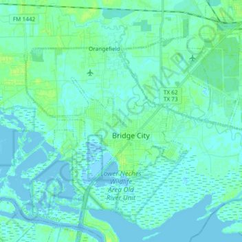
Name: Bridge City topographic map, elevation, terrain.

Location: Bridge City, Orange County, Texas, 77611, United States (29.99477 -93.90504 30.07900 -93.75771)

Average elevation: 3 m

Minimum elevation: -1 m

Maximum elevation: 9 m

Other topographic maps

Click on a map to view its topography, its elevation and its terrain.

Toledo Bend

United States > Texas > Orange County

Average elevation: 4 m

Cove

United States > Texas > Orange County > Orange

Average elevation: 3 m

Brownwood

United States > Texas > Orange County > Orange

Average elevation: 4 m

Lemonville

United States > Texas > Orange County

Average elevation: 7 m

Gear up for your next adventure:

🪑Ultralight Camping Stool - Compact seating for rest stops during long hikes
🎒Hiking Backpack - Lightweight and ergonomic backpacks for day hikes or multi-day treks
🥾Mountain Trail Shoes - High-traction shoes for mountain trails
🧭Orienteering Kit - Tools for map reading and navigation in the wild
🏕️Camping Hammock - Integrated protection for sleeping between trees

As an Amazon Associate, this site earns from qualifying purchases at no extra cost to you.