Geolocate

Poggioreale topographic map

Click on the map to display elevation.

About this map
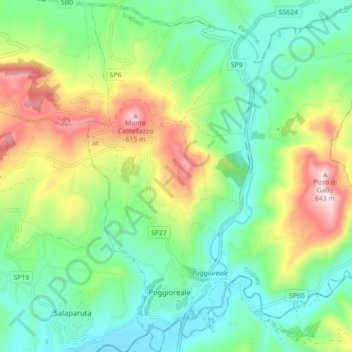
Name: Poggioreale topographic map, elevation, terrain.

Location: Poggioreale, Trapani, Sicily, 91020, Italy (37.75015 13.01348 37.82062 13.10014)

Average elevation: 282 m

Minimum elevation: 107 m

Maximum elevation: 635 m

Other topographic maps

Click on a map to view its topography, its elevation and its terrain.

Isola San Pantaleo

Italy > Sicily > Trapani > Marsala

Average elevation: 1 m

Scopello

Italy > Sicily > Trapani > Castellammare del Golfo

Average elevation: 150 m

Trapani

Italy > Sicily > Trapani > Trapani

Average elevation: 46 m

Nubia

Italy > Sicily > Trapani > Paceco

Average elevation: 4 m

Macari

Italy > Sicily > Trapani

Average elevation: 225 m

Segesta

Italy > Sicily > Trapani > Calatafimi Segesta

Average elevation: 269 m

Isola San Pantaleo

Italy > Sicily > Trapani > Marsala

Average elevation: 1 m

Nubia

Italy > Sicily > Trapani > Paceco

Average elevation: 4 m

Monte Casal Monaco

Italy > Sicily > Trapani > Trapani

Average elevation: 453 m

Mursía

Italy > Sicily > Trapani > Pantelleria

Average elevation: 40 m

Gear up for your next adventure:

🚑Survival Whistle - Signal for help across long distances in mountains
👖Convertible Hiking Pants - Zip-off legs to adapt to changing weather conditions
🥾Waterproof Hiking Boots - Essential footwear for rugged terrain and wet Canadian trails
🪑Insulated Seat Pad - Protect your seat from cold rocks and wet logs
🐕Hiking Dog Pack - Let your canine companion carry their own water and food

As an Amazon Associate, this site earns from qualifying purchases at no extra cost to you.