
Make a donation
Gear up for your next adventure:
As an Amazon Associate, this site earns from qualifying purchases at no extra cost to you.
Fougerolles topographic map
Click on the map to display elevation.
Make a donation
Gear up for your next adventure:
As an Amazon Associate, this site earns from qualifying purchases at no extra cost to you.
About this map
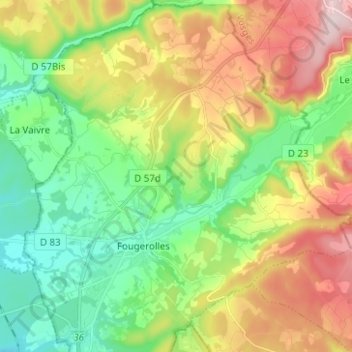
Name: Fougerolles topographic map, elevation, terrain.
Average elevation: 399 m
Minimum elevation: 265 m
Maximum elevation: 613 m
Make a donation
Gear up for your next adventure:
As an Amazon Associate, this site earns from qualifying purchases at no extra cost to you.
Other topographic maps
Click on a map to view its topography, its elevation and its terrain.
Fougerolles
France > Bourgogne-Franche-Comté > Haute-Saône > Fougerolles-Saint-Valbert
Average elevation: 340 m
Blanzey
France > Bourgogne-Franche-Comté > Haute-Saône > Fougerolles-Saint-Valbert
Average elevation: 389 m
Le Petit Fahys
France > Bourgogne-Franche-Comté > Haute-Saône > Fougerolles-Saint-Valbert
Average elevation: 367 m