
Make a donation
Gear up for your next adventure:
As an Amazon Associate, this site earns from qualifying purchases at no extra cost to you.
Langdon Hill topographic map
Click on the map to display elevation.
Make a donation
Gear up for your next adventure:
As an Amazon Associate, this site earns from qualifying purchases at no extra cost to you.
About this map
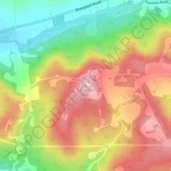
Name: Langdon Hill topographic map, elevation, terrain.
Location: Langdon Hill, Chemung County, New York, 14838, United States (42.16641 -76.69306 42.16651 -76.69296)
Average elevation: 449 m
Minimum elevation: 348 m
Maximum elevation: 541 m
Make a donation
Gear up for your next adventure:
As an Amazon Associate, this site earns from qualifying purchases at no extra cost to you.
Other topographic maps
Click on a map to view its topography, its elevation and its terrain.
Breesport
United States > New York > Chemung County > Town of Horseheads
Breesport is located on the eastern side of the town of Horseheads at 42°10′24″N 076°44′02″W / 42.17333°N 76.73389°W / 42.17333; -76.73389 (42.173408, -76.733841). Its elevation is 1,099 feet (335 m). Its eastern edge is the border between Horseheads and the town of Erin. New York State…
Average elevation: 374 m
Make a donation
Gear up for your next adventure:
As an Amazon Associate, this site earns from qualifying purchases at no extra cost to you.
Village of Horseheads
United States > New York > Chemung County > Town of Horseheads
Average elevation: 298 m
Make a donation
Gear up for your next adventure:
As an Amazon Associate, this site earns from qualifying purchases at no extra cost to you.
Make a donation
Gear up for your next adventure:
As an Amazon Associate, this site earns from qualifying purchases at no extra cost to you.