Geolocate

Onalaska topographic map

Click on the map to display elevation.

Onalaska

The city's terrain is characterized by gently rolling hills and piney woods typical of the East Texas Timberlands region. Elevations within Onalaska range from approximately 128 feet (39 m) to 253 feet (77 m) above sea level, with an average elevation around 161 feet (49 m).

Wikipedia (CC-BY-SA 3.0)

About this map

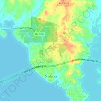
Name: Onalaska topographic map, elevation, terrain.

Location: Onalaska, Polk County, Texas, 77360, United States (30.79285 -95.15635 30.84829 -95.08862)

Average elevation: 49 m

Minimum elevation: 39 m

Maximum elevation: 77 m

Other topographic maps

Click on a map to view its topography, its elevation and its terrain.

Moscow

United States > Texas > Polk County

Average elevation: 98 m

Pluck

United States > Texas > Polk County

Average elevation: 61 m

Segno

United States > Texas > Polk County

Average elevation: 60 m

Schwab City

United States > Texas > Polk County

Average elevation: 66 m

Tobacco Patch

United States > Texas > Polk County

Average elevation: 43 m

Israel

United States > Texas > Polk County

Average elevation: 87 m

Gear up for your next adventure:

🛶Canoe Life Vest - Safety vest for water sports
🎒Hiking Daypack - Lightweight and durable backpacks for day trips and excursions
🕶️Polarized Sunglasses - Protect your eyes with durable polarized lenses
🥾Trail Running Boots - Durable shoes designed for trail running
🧴First Aid Kit - Essential first aid supplies for outdoor emergencies

As an Amazon Associate, this site earns from qualifying purchases at no extra cost to you.