
Make a donation
Gear up for your next adventure:
As an Amazon Associate, this site earns from qualifying purchases at no extra cost to you.
La Florida topographic map
Click on the map to display elevation.
Make a donation
Gear up for your next adventure:
As an Amazon Associate, this site earns from qualifying purchases at no extra cost to you.
About this map
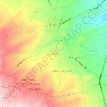
Name: La Florida topographic map, elevation, terrain.
Location: La Florida, Tisaleo, Tungurahua, Ecuador (-1.37972 -78.68929 -1.33972 -78.64929)
Average elevation: 3,290 m
Minimum elevation: 3,008 m
Maximum elevation: 3,557 m
Make a donation
Gear up for your next adventure:
As an Amazon Associate, this site earns from qualifying purchases at no extra cost to you.
Other topographic maps
Click on a map to view its topography, its elevation and its terrain.
Tisaleo
Ecuador > Tungurahua > Tisaleo
Tisaleo luchó por su cantonización desde 1980, una comisión que viajó a Quito sufrió un trágico accidente; consiguió la elevación a Cantón el17 de noviembre de 1987.[2]
Average elevation: 3,244 m