Geolocate

Lavonia topographic map

Click on the map to display elevation.

About this map

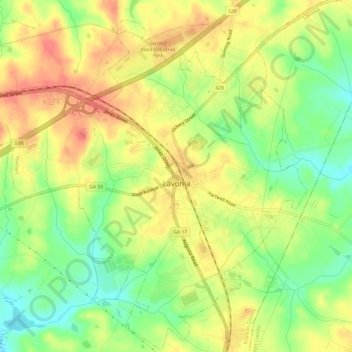
Name: Lavonia topographic map, elevation, terrain.

Location: Lavonia, Franklin County, Georgia, 30553, United States (34.41189 -83.14199 34.46075 -83.08226)

Average elevation: 249 m

Minimum elevation: 217 m

Maximum elevation: 275 m

Other topographic maps

Click on a map to view its topography, its elevation and its terrain.

Prospect

United States > Georgia > Franklin County

Average elevation: 233 m

Martin Pond

United States > Georgia > Franklin County

Average elevation: 226 m

Ashland

United States > Georgia > Franklin County

Average elevation: 236 m

Gear up for your next adventure:

👟Trail Running Shoes - Agile footwear for fast-paced topographic exploration
🎒Hiking Daypack - Lightweight and durable backpacks for day trips and excursions
🥾Trekking Boots - Durable boots for long-distance trekking
🧶550 Survival Paracord - Versatile utility cord for emergency repairs and rigging
🥾Approach Shoes - Shoes designed for climbing approaches and rugged trails

As an Amazon Associate, this site earns from qualifying purchases at no extra cost to you.