Geolocate

Altos do Fiouco topographic map

Click on the map to display elevation.

About this map

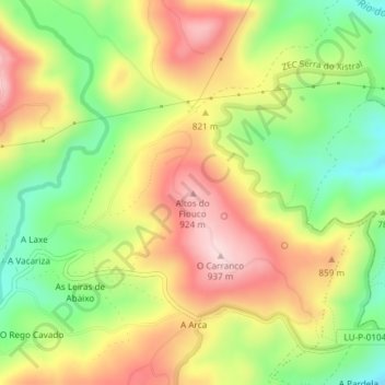
Name: Altos do Fiouco topographic map, elevation, terrain.

Location: Altos do Fiouco, Abadín, Tierra Chá, Lugo, Galicia, España (43.43178 -7.55139 43.43188 -7.55129)

Average elevation: 794 m

Minimum elevation: 658 m

Maximum elevation: 932 m

Other topographic maps

Click on a map to view its topography, its elevation and its terrain.

Moncelos

España > Galicia > Tierra Chá > Abadín

Average elevation: 443 m

Gear up for your next adventure:

💡Solar Camping Lamp - Eco-friendly lighting for campsites
🧭GPS Handheld Device - Reliable GPS navigation for outdoor adventures
🧦Hiking Liner Socks - Thin base layer to prevent friction and blisters
🥾Light Hiking Boots - Lightweight and comfortable boots for day hikes
🎒Hiking Daypack - Lightweight and durable backpacks for day trips and excursions

As an Amazon Associate, this site earns from qualifying purchases at no extra cost to you.