
Make a donation
Gear up for your next adventure:
As an Amazon Associate, this site earns from qualifying purchases at no extra cost to you.
Palo Gacho topographic map
Click on the map to display elevation.
Make a donation
Gear up for your next adventure:
As an Amazon Associate, this site earns from qualifying purchases at no extra cost to you.
About this map
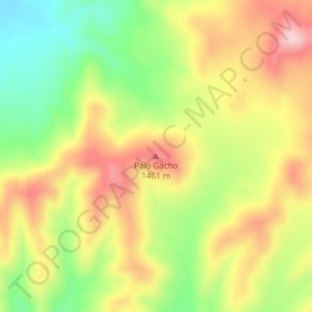
Name: Palo Gacho topographic map, elevation, terrain.
Location: Palo Gacho, Municipio de Tecate, Baja California, Mexico (32.36832 -116.17228 32.36842 -116.17218)
Average elevation: 1,382 m
Minimum elevation: 1,269 m
Maximum elevation: 1,492 m
Make a donation
Gear up for your next adventure:
As an Amazon Associate, this site earns from qualifying purchases at no extra cost to you.
Other topographic maps
Click on a map to view its topography, its elevation and its terrain.
Tecate
Mexico > Baja California > Municipio de Tecate
Tecate's altitude of approximately 540 m (1,770 ft) above sea level and its proximity to the ocean contribute to the temperate climate. It rains enough in the area (almost 360 mm [14 in] per year) for a thick ground cover of shrubs and scattered trees to grow.
Average elevation: 595 m