Geolocate

Weiher topographic map

Click on the map to display elevation.

About this map

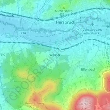
Name: Weiher topographic map, elevation, terrain.

Location: Weiher, Hersbruck, Landkreis Nürnberger Land, Bayern, 91217, Deutschland (49.47659 11.40259 49.51659 11.44259)

Average elevation: 387 m

Minimum elevation: 328 m

Maximum elevation: 610 m

Other topographic maps

Click on a map to view its topography, its elevation and its terrain.

Gear up for your next adventure:

🔦LED Flashlight - Powerful and long-lasting flashlight for camping and emergencies
🏃Hydration Running Vest - Carry water and maps close to your body for speed
🌬️Windproof Camp Stove - Efficient cooking even on exposed mountain peaks
🧦Outdoor Socks - Durable socks designed for hiking and outdoor sports
🌡️Emergency Mylar Blankets - Compact thermal protection for unexpected nights outdoors

As an Amazon Associate, this site earns from qualifying purchases at no extra cost to you.