
Make a donation
Gear up for your next adventure:
As an Amazon Associate, this site earns from qualifying purchases at no extra cost to you.
Ropczyce topographic map
Click on the map to display elevation.
Make a donation
Gear up for your next adventure:
As an Amazon Associate, this site earns from qualifying purchases at no extra cost to you.
Ropczyce
Ropczyce is located east of Kraków and west of Rzeszów. The coordinates for Ropczyce: Latitude 50°0500' and Longitude 21°6167. In DMS or Degree, Minutes, & Seconds; Latitude 50°2'60N and Longitude is 21°37'0E. Its elevation is 240 metres (787 feet) above sea level. The time zone for Poland is UTC+1.
Make a donation
Gear up for your next adventure:
As an Amazon Associate, this site earns from qualifying purchases at no extra cost to you.
About this map
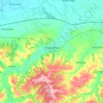
Name: Ropczyce topographic map, elevation, terrain.
Average elevation: 250 m
Minimum elevation: 190 m
Maximum elevation: 382 m
Make a donation
Gear up for your next adventure:
As an Amazon Associate, this site earns from qualifying purchases at no extra cost to you.