Geolocate

Nidderau topographic map

Click on the map to display elevation.

About this map

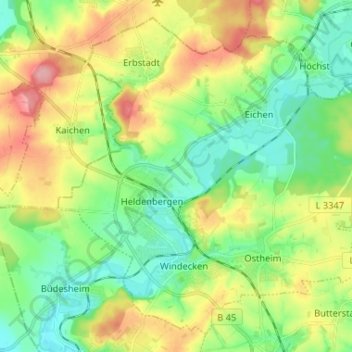
Name: Nidderau topographic map, elevation, terrain.

Location: Nidderau, Main-Kinzig-Kreis, Hesse, 61130, Germany (50.20609 8.83254 50.28116 8.96278)

Average elevation: 153 m

Minimum elevation: 110 m

Maximum elevation: 226 m

Other topographic maps

Click on a map to view its topography, its elevation and its terrain.

Ramholz

Germany > Hesse > Main-Kinzig-Kreis > Vollmerz

Average elevation: 373 m

Hanau

Germany > Hesse > Main-Kinzig-Kreis > Hanau

Average elevation: 110 m

Gear up for your next adventure:

🧥Thermal Layer - Insulating layer for cold outdoor conditions
Backpacking Tent - Lightweight tent for long-distance hiking trips
🌬️Windproof Camp Stove - Efficient cooking even on exposed mountain peaks
❄️Traction Ice Cleats - Slip-on spikes for icy trails and winter hiking
🚲Bike Repair Kit - Essential tools for on-trail mechanical issues

As an Amazon Associate, this site earns from qualifying purchases at no extra cost to you.