
Make a donation
Gear up for your next adventure:
As an Amazon Associate, this site earns from qualifying purchases at no extra cost to you.
Vals-près-le-Puy topographic map
Click on the map to display elevation.
Make a donation
Gear up for your next adventure:
As an Amazon Associate, this site earns from qualifying purchases at no extra cost to you.
About this map
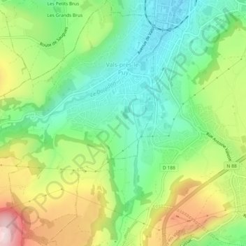
Name: Vals-près-le-Puy topographic map, elevation, terrain.
Average elevation: 759 m
Minimum elevation: 626 m
Maximum elevation: 979 m
Make a donation
Gear up for your next adventure:
As an Amazon Associate, this site earns from qualifying purchases at no extra cost to you.
Other topographic maps
Click on a map to view its topography, its elevation and its terrain.
Cheneville
France > Auvergne-Rhône-Alpes > Haute-Loire > Varennes-Saint-Honorat
Average elevation: 1,055 m
Make a donation
Gear up for your next adventure:
As an Amazon Associate, this site earns from qualifying purchases at no extra cost to you.
Laniac
France > Auvergne-Rhône-Alpes > Haute-Loire > Siaugues-Sainte-Marie > Siaugues-Saint-Romain
Average elevation: 909 m
Chambonnet
France > Auvergne-Rhône-Alpes > Haute-Loire > Saint-Préjet-d'Allier
Average elevation: 974 m
Make a donation
Gear up for your next adventure:
As an Amazon Associate, this site earns from qualifying purchases at no extra cost to you.
Make a donation
Gear up for your next adventure:
As an Amazon Associate, this site earns from qualifying purchases at no extra cost to you.