
Town of Malta topographic map
Interactive map
Click on the map to display elevation.
About this map
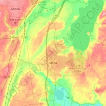
Name: Town of Malta topographic map, elevation, terrain.
Average elevation: 91 m
Minimum elevation: 36 m
Maximum elevation: 140 m
Other topographic maps
Click on a map to view its topography, its elevation and its terrain.
Town of Halfmoon
United States > New York > Saratoga County
Town of Halfmoon, Saratoga County, New York, 12118, United States
Average elevation: 73 m
Town of Moreau
United States > New York > Saratoga County
Town of Moreau, Saratoga County, New York, United States
Average elevation: 115 m
Village of Ballston Spa
United States > New York > Saratoga County > Town of Milton > Village of Ballston Spa
Village of Ballston Spa, Town of Milton, Saratoga County, New York, United States
Average elevation: 97 m