Geolocate

Gopalpur topographic map

Click on the map to display elevation.

About this map

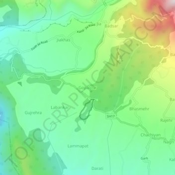
Name: Gopalpur topographic map, elevation, terrain.

Location: Gopalpur, Palampur, Kangra, Himachal Pradesh, 176059, India (32.12362 76.43444 32.16362 76.47444)

Average elevation: 1,284 m

Minimum elevation: 1,050 m

Maximum elevation: 1,800 m

Other topographic maps

Click on a map to view its topography, its elevation and its terrain.

Nanahar

India > Himachal Pradesh > Palampur

Average elevation: 1,610 m

Dhauladhar

India > Himachal Pradesh > Palampur

Average elevation: 2,577 m

Banuri

India > Himachal Pradesh > Palampur

Average elevation: 1,254 m

Neugal Rivulet

India > Himachal Pradesh > Palampur

Average elevation: 1,019 m

Kandbari

India > Himachal Pradesh > Palampur

Average elevation: 1,424 m

Gear up for your next adventure:

💧Hydration Pack - Hands-free hydration system for long hikes
🥾Hiking Shoes - Durable and comfortable shoes for trail hiking
Camping Coffee Maker - Brew fresh coffee anywhere on the topographic map
🚲Bike Repair Kit - Essential tools for on-trail mechanical issues
🧢Outdoor Cap - Protective cap for sun and rain during hikes

As an Amazon Associate, this site earns from qualifying purchases at no extra cost to you.