
Make a donation
Gear up for your next adventure:
As an Amazon Associate, this site earns from qualifying purchases at no extra cost to you.
Rocky Butte topographic map
Click on the map to display elevation.
Make a donation
Gear up for your next adventure:
As an Amazon Associate, this site earns from qualifying purchases at no extra cost to you.
About this map
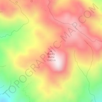
Name: Rocky Butte topographic map, elevation, terrain.
Average elevation: 782 m
Minimum elevation: 421 m
Maximum elevation: 1,033 m
Make a donation
Gear up for your next adventure:
As an Amazon Associate, this site earns from qualifying purchases at no extra cost to you.
Other topographic maps
Click on a map to view its topography, its elevation and its terrain.
Morro Strand State Beach
United States > California > San Luis Obispo County > Morro Bay
Average elevation: 64 m
Morro Bay State Park
United States > California > San Luis Obispo County > Morro Bay
Average elevation: 37 m
Montaña de Oro State Park
United States > California > San Luis Obispo County > Cuesta-by-the-Sea
Average elevation: 94 m
Make a donation
Gear up for your next adventure:
As an Amazon Associate, this site earns from qualifying purchases at no extra cost to you.
Laguna Lake
United States > California > San Luis Obispo County > San Luis Obispo
Average elevation: 63 m