
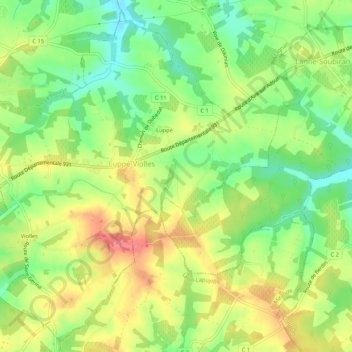
Luppé-Violles topographic map
Interactive map
Click on the map to display elevation.
About this map
Name: Luppé-Violles topographic map, elevation, terrain.
Average elevation: 131 m
Minimum elevation: 97 m
Maximum elevation: 167 m
Other topographic maps
Click on a map to view its topography, its elevation and its terrain.
Saint-Mézard
Saint-Mézard, Condom, Gers, Occitanie, France métropolitaine, 32700, France
Average elevation: 146 m
Bellegarde
Bellegarde, Mirande, Gers, Occitanie, France métropolitaine, 32140, France
Average elevation: 256 m
Saint-Antonin
France > Occitanie > Gers > Saint-Antonin
Saint-Antonin, Condom, Gers, Occitanie, France métropolitaine, 32120, France
Average elevation: 175 m
Saint-Justin
Saint-Justin, Mirande, Gers, Occitanie, France métropolitaine, 32230, France
Average elevation: 187 m