
Make a donation
Gear up for your next adventure:
As an Amazon Associate, this site earns from qualifying purchases at no extra cost to you.
Sugar Loaf Mountain topographic map
Click on the map to display elevation.
Make a donation
Gear up for your next adventure:
As an Amazon Associate, this site earns from qualifying purchases at no extra cost to you.
About this map
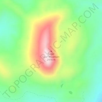
Name: Sugar Loaf Mountain topographic map, elevation, terrain.
Location: Sugar Loaf Mountain, Routt County, Colorado, United States (40.78325 -107.18400 40.78335 -107.18390)
Average elevation: 2,800 m
Minimum elevation: 2,635 m
Maximum elevation: 3,063 m
Make a donation
Gear up for your next adventure:
As an Amazon Associate, this site earns from qualifying purchases at no extra cost to you.
Other topographic maps
Click on a map to view its topography, its elevation and its terrain.
Yampa
United States > Colorado > Routt County
Yampa has a humid continental climate (Köppen climate classification Dfb), with warm summers and long, cold, snowy winters. Due to altitude and dryness, the diurnal temperature variation is large throughout the year, especially in summer, and the growing season is short, typically averaging just 80 days.
Average elevation: 2,422 m
Make a donation
Gear up for your next adventure:
As an Amazon Associate, this site earns from qualifying purchases at no extra cost to you.
Make a donation
Gear up for your next adventure:
As an Amazon Associate, this site earns from qualifying purchases at no extra cost to you.